Clydebank Sights
Clydebank
47 metres climb
Risk assessed route
Distance - 11.4 miles
Bike suitability - Mountain Bike, Hybrid (off road tyres), Hybrid (road tyres), Road
About the route
Starting point
Outside McMonagles Fish Restaurant
On the Forth & Clyde Canal adjacent to Argyll Road
Clydebank
Lanarkshire
G81 1QA
Forth & Clyde Canal
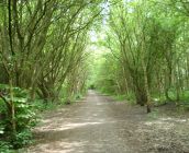
An 11 mile circular route on Clydebank's gentle, meandering cycle path. The route follows the northern flank of the Clyde westwards, through the towns of Old Kilpatrick, Bowling and Milton, taking in the sights of the Forth and Clyde canal and the Roman fort at Milton, once part of the Antonine Wall. The route is largely traffic-free, mostly flat and suitable for road bikes, following tarmac paths and quiet roads.